Transiting The Panama Canal By Sailboat

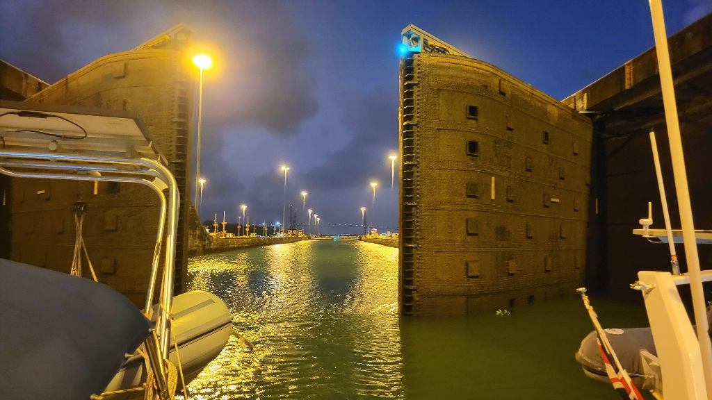
The Panama Canal, called “the path between the seas,” is the easiest route from the Caribbean to the Pacific. Completed over 100 years ago, it is a man-made marvel of engineering. Transiting the Panama Canal by sailboat is a bucket-list activity for those trying to circumnavigate, or get between oceans.

The land divided, the world united.

Motto of The Panama Canal

Hiring an Agent Versus DIY

It takes a lot of paperwork to get through the canal! We used an agent to alleviate some of the work. As Panama Posse members, we get a discount on the Canal agent. It saved us a lot of time, paperwork, and hassle. While it may be cheaper, if you don’t use an agent, you have to pay everything in cash. This means multiple trips to ATMs, which have very low maximum daily withdrawals. ATMs aren’t easily accessible outside of Panama City.

How Much Does it Cost?

Transiting The Panama Canal on a sailboat isn’t cheap, even for a boat under 65 feet! Here’s a breakdown on current pricing to transit:

Continue reading “Transiting The Panama Canal By Sailboat”

Bocas del Toro Boat Life

We’re in our second month in the archipelago of Bocas del Toro, Panama. Time is flying! We’re keeping busy, seeing the sights, and spending time with fellow cruisers. Here’s an overview of Bocas del Toro boat life.

About Bocas del Toro

Bocas del Toro (or Bocas, familiarly) is a province on the Caribbean side of Panama. Part of it is located on the mainland, but the important part is the chain of islands. Bocas del Toro means Mouth of the Bull, and the island chain has 3 big islands and many smaller islets and atolls.

Bocas del Toro on a map
Map of Bocas del Toro Panama

Bocas del Toro is a popular tourist destination, and the site of many banana plantations. It has an airport, with several daily flights from Panama City, and multiple water ferries and taxis from the mainland.

There are three big islands in Bocas del Toro, where most of the activity happens and the majority of people live and work.

Bocas del Toro map mural
Isla Colon

Isla Colon is the main island, with the airport and main town, called Bocas Town. That’s where the stores are and lots of hotels and resorts. It’s the “big island” where we go to provision at the supermarkets.

Isla Carenero

Right across from Isla Colon, Carenero has a small marina, and many resorts, beaches, and restaurants.

Marina on Isla Carenero
Continue reading “Bocas del Toro Boat Life”

Sailing in Colombia

Sailing in Colombia is different from the ideal conditions in the Eastern Caribbean: trips are a lot longer and other cruiser boats not as common. Conditions can be rough, with strong winds, and navigating is challenging with incomplete charts. Because of these difficulties, some cruisers don’t stop here at all on the way to Panama, and others only visit one port: Santa Marta or Cartagena. As longtime fans of Colombia, we spent extended time in both! Here’s what our experience has been sailing in Colombia.

Western Caribbean map including Colombia
Colombia in the Western Caribbean

All information in this post is based on our experiences sailing the Caribbean coast of mainland Colombia. The country is vast, with Pacific coastline and occupied islands alongside Central America, which are not discussed here.

Welcome to Colombia

Arriving in Colombia on our boat was different from other sailing destinations. Colombia is so big that we saw the country a full day before we could enter a port. And the conditions are rough. Santa Marta, Colombia is infamous for heavy winds and rough seas, so much so that many sailors coming from the ABC Islands or further choose to skip the port entirely and head straight to Cartagena.

rough seas Colombia
Rough seas in Colombia
Continue reading “Sailing in Colombia”